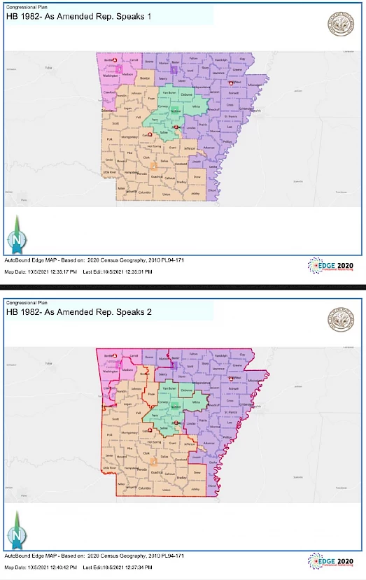
On October 7th, the Arkansas General Assembly recently approved a new map for Arkansas's 4 congressional districts. The task of updating these maps was required following the latest census data. The boundaries do carry general similarities to the current map, which was established a decade ago following the previous census report. Population declines occurred in the first and fourth congressional districts, while the second and third districts saw population increases. While several proposed maps were considered, the map featured below prevailed in the end. The proposal now goes to Governor Hutchinson for consideration before enactment.
The most controversial aspect of this new map is Pulaski County where the county was divided up into three districts with some cities, including Little Rock and North Little Rock, divided among districts. Within these divisions were areas with substantial minority populations. It's expected that for this reason, this map may end up challenged in court.
The bills failed to receive the required 24 Senate votes to carry an emergency clause to expedite enactment. If approved by the Governor, the new maps would officially be enacted 90 days from being signed into law.
More below:
https://www.arkleg.state.ar.us/Bills/Detail?id=HB1982&ddBienniumSession=2021%2F2021R&Search=
https://www.arkleg.state.ar.us/Bills/Detail?id=sb743&ddBienniumSession=2021%2F2021R&Search=
https://talkbusiness.net/2021/10/congressional-redistricting-maps-advance-at-state-legislature/
https://www.arkansasonline.com/news/2021/oct/07/state-legislature-sends-redistricting-bills-govern/